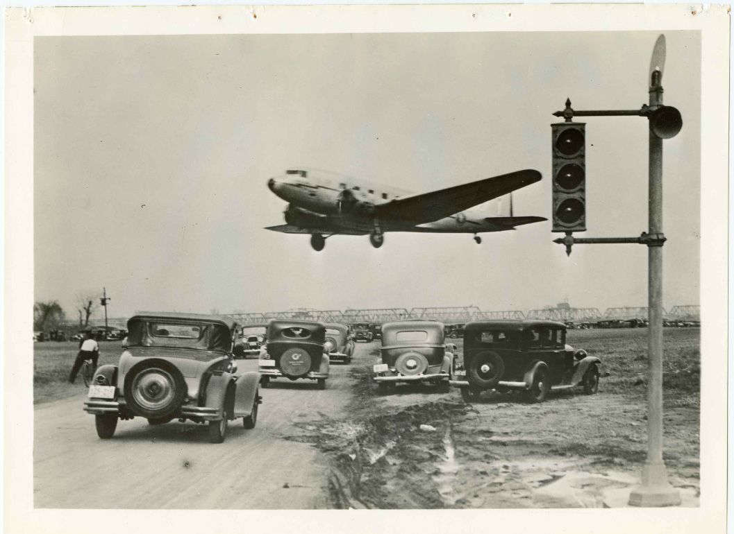
A passenger plane roars low over a row of parked automobiles at Hoover Field in Arlington County, Virginia, in this striking 1930s photograph. The image captures the precarious coexistence of aviation and everyday life at what was considered one of the most hazardous airfields in the United States — a place where cars on Military Road had to stop for planes crossing the road to reach the runway, and where pilots navigated short, unpaved strips flanked by telephone poles, smokestacks, and a smoldering garbage dump.
Hoover Field was constructed as a private airfield in 1925 and opened for public commercial use on July 16, 1926. Located near the intersection of today’s 14th Street Bridge and the George Washington Memorial Parkway, the airport occupied the very ground where the Pentagon and its northern parking lots now stand. The field was named after Herbert Hoover, who was then Secretary of Commerce and oversaw aviation regulation before becoming president in 1929.
Despite its dangerous conditions — poor drainage, limited visibility, and alarming near-misses with ground traffic — Hoover Field was the primary commercial airport serving Washington, D.C. during the late 1920s. A rival facility called Washington Airport operated on an adjacent parcel, and the two fields merged in 1933 to form Washington-Hoover Airport. Even combined, the airport remained notoriously unsafe, with planes routinely buzzing over cars on Military Road (present-day Route 1) during takeoff and landing. A traffic light system was installed to halt automobiles when aircraft needed to cross, a scene almost unimaginable by today’s standards.
Washington-Hoover Airport closed in June 1941 when Washington National Airport — now Ronald Reagan Washington National Airport — opened as its replacement just one mile to the south along the Potomac. Within two years, the old airfield vanished entirely beneath the construction of the Pentagon, which broke ground in September 1941. This photograph is a rare glimpse of the brief, chaotic era when commercial aviation was finding its footing in the nation’s capital, quite literally at ground level.
Source: “Low Flying Plane,” circa 1930s. Black and white photograph, 7.5 x 10 inches. RG 13: Samuel Milner National Airport Research Papers, Series 6: Photographs, File 1: Hoover Field (Identifier: 13-06-01-5109). Charlie Clark Center for Local History, Arlington Public Library. View original record.